This trip was long planned beforehand. After some research on Tripadvisor and similar sites we contacted Januzak from Pamir offroad adventures. He offered us a fair price, ~ 1600 US-$ including transport, food and accomodation. In hindsight this wasn’t expensive, most of the money seems to be used for petrol and maintaince of the car. For example the shock absorbers have to be changed twice per tourist season (=summer), the engine is renewed every 2-3 years. If you are on a budget, cheaper tours can be organised from some hostels in Osh (gather some fellas and share the cost of a jeep, which is usually calculated per km), some backpackers even do this trip with public transport, which is possible, but needs some great flexibility.
The typical itineries are 5d/4n including Wakhan Valley, some people opt to use the classical Pamir highway (heading east in Khorog) and make it a 4d/3n tour. Surprisingly many cyclists roam the streets. Be sure to buy this excellent Swiss map of the Pamir region.
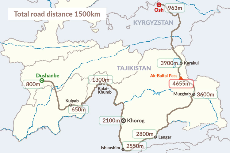
We opted for the classical 5d/4n tour. In hindsight the direction was much better than the Osh-Dushanbe-route, as acclimatisation was much easier.
Day 1: Dushanbe – Khalaikum (400 km)
The first part of this trip isn’t that interesting. We had to stop one hour to replace the fuel pump, but our guide’s 2nd job seemed to be a car mechanics – he even had a spare engine loaded. The most interesting point is Shar-shar pass for a view of the Nurek dam.


After lunch in Kulob we came up Panj river, which marks the border to Afghanistan. We followed this river until the end of day 3. It was very interesting to observe everyday life on the Afghan side, sometimes the river is so narrow, that you can literally throw a stone into Afghanistan.


Day 2: Khalaikum – Khorog (Chorog), 250 km
The second day covers only 250 km, but this on a very bad road. We continuously followed Panj river and the Tajik-Afghan border. When observing the Afghan side of the river, it seems like a look in the past.


Khorog is the capital of the Gorno-Badakshan Autonomous Oblast (be sure to add this region in your e-visa-application!) and surprisingly well developed. We enjoyed a quite nice hotel, before we slept in very simple home stays the next two days. Altitude is also becoming an issue, but luckily we didn’t encounter any signs of altitude sickness.


Day 3: Khorog – Langar (350 km)
On this long day we went through the Wakhan valley. The road is not excellent, but could be much worse considering the remoteness of the area.
First side trip was to the village of Garmanchashma, famous for its hot springs. From a view point a few kilometers south an Afghan village can be observed. Lunch was next to the Bibi-Fatima hot springs (named for the Prophet Mohammed’s daughter, the water is said to increase the fertility of local women), near the Yamchun fortress, dated to the 3rd-1st century BC. A last stop was at a Buddhist stupa in Vrang (4th century AD). We stayed the night in a guest house with very basic facilities.


Day 4: Langar – Murghab (310 km)
On day 4 we finally left Panj river and the Afghan border. We crossed Kargush pass (4344 m), before reaching the junction of the Pamir highway. We turned west for a detour to the village of Bulunkul and the lakes Bulunkul and Yashilkul. We stayed the last night of the road trip in Murghab. Although quite a big village, there’s not even regular electricity, and facilities are basic. Murghab lies on 3600 m, so expect some signs of altitude sickness.


Day 5: Murghab – Osh (400 km)
On the last day we crossed Akhaital pass (4655 m) and approached Karakul lake (3923 m). Snow-capped mountains were always visible in the background, among them Peak Lenin (7134m). Kizilart pass (4270m) forms the border between Tajikistan and Kyrgyzstan. After crossing the border we reached the town of Sary Tash, where we had our last lunch. After that the landscape became visibly greener, before we finally arrived in the soaring heat of Osh city.


Next: Osh
